The Global Positioning System (GPS)
Rev. 18 February 2024
The Global Positioning System (GPS) is a satellite-based system that enables accurate capture of location anyplace on the surface of the planet. While radio navigation aids for aviation have been used since 1908 and the first military satellite-based navigation system (TRANSIT) became operational in 1964 (PDF), the deployment of the Global Positioning System beginning in 1978 has made location tracking an integral part of commercial, military and private life in the developed world.
There are other satellite-based systems besides the US GPS system and satellite navigation systems are sometimes referred to by the more generic acronym GNSS (global navigation satellite system).
GPS Segments
While we commonly think of GPS as a collection of satellites, it is more helpful to think of GPS as a system with three segments:
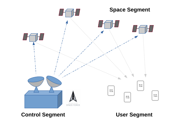
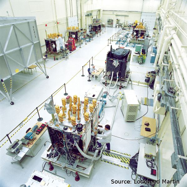
The space segment consists of a constellation of around 32 satellites, each in a circular orbit 12,552 miles above the earth that takes 11 hours and 58 minutes to go around the earth. The satellites contain extremely accurate atomic clocks and transmit signals with the time of transmission and the location and orbit of the satellite on 1,575.42 mHz and 1,227.6 mHz.
The control segment is a set of ground stations that manage the satellites.
- The master control station is located at Schriever Space Force Base in Colorado Springs, CO, with a backup station at Vandenberg Air Force Base in California.
- Six original monitor stations are located at Schriever Space Force Base in Colorado, Cape Canaveral, Florida, Hawaii, Ascension Island in the Atlantic Ocean, Diego Garcia Atoll in the Indian Ocean, and Kwajalein Island in the South Pacific Ocean.
- Six additional stations were added in 2005 in Argentina, Bahrain, United Kingdom, Ecuador, Washington DC, and Australia.
- There are additional ground antennas and NGA monitor stations around the world.
The user segment is the GPS receivers that actually use the GPS signals to find location. GPS receivers range from inexpensive receivers in cellphones to complex, highly-accurate receivers used in surveying.
Trilateration
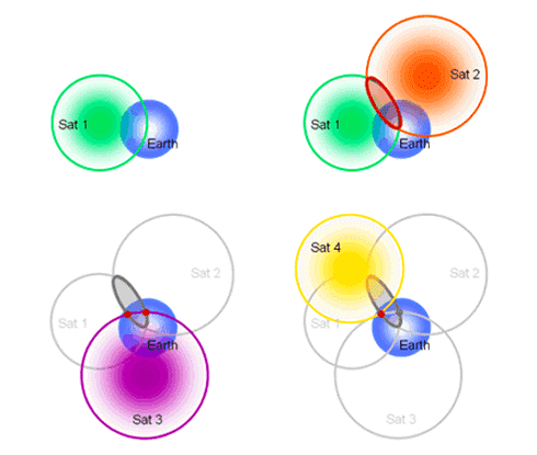
Radio signals travel at the speed of light, and the delay between the time a signal is transmitted by a GPS satellite and the time the signal is received by a receiver is key to the operation of GPS.
- The satellites contain highly-accurate, synchronized atomic clocks, and the GPS signals contain the time of transmission and location in orbit when the signals are transmitted (ephemeris data).
- Trilateration is a technique where a GPS receiver uses the differences in delays between the signals along with 3-dimensional geometric calculations to determine the latitude, longitude and elevation of the receiver.
- While the tri part of trilateration implies three, and it is possible to calculate location from three GPS signals if the receiver has a high-precision clock, very few GPS receivers have such clocks, so almost all GPS receivers need at least four signals to accurately calculate location. Averaging using signals from additional receivers beyond the minimum four signals can improve accuracy.
- GPS receivers calculate time, latitude, longitude and elevation based on the WGS 84 datum, although high-end receivers can transform and display coordinates in other datums and coordinate systems.
GPS Apps
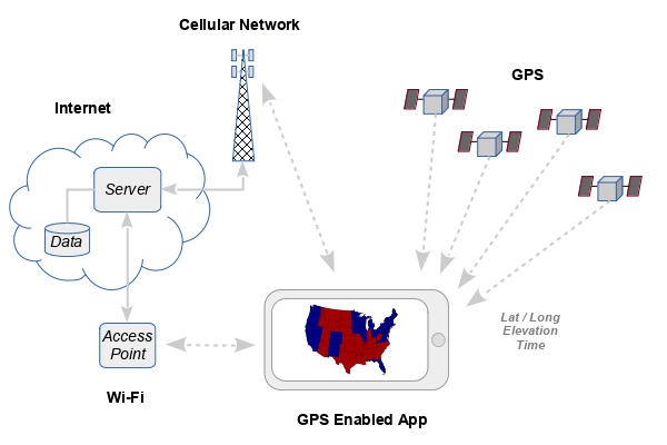
The term GPS is commonly used to refer not just the satellite technology, but also to consumer devices and apps that use GNSS in conjunction with other non-satellite geographic information to aid in navigation and tracking.
GPS signals only go in one direction from the satellites to the users, and any additional information associated with GPS location (such as driving directions) must be stored in the app and / or acquired through terrestrial Wi-Fi or cellular networks.
GPS Availability and Accuracy
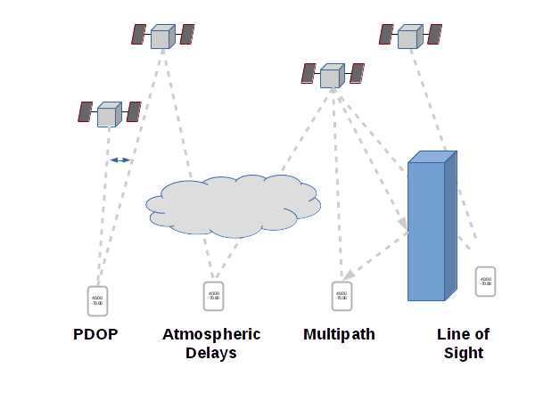
There are numerous factors that affect the availability and accuracy of GPS location calculation. Some of these are minor for casual GPS use, but the can be important when highly accurate GPS locations are needed (as in surveying).
- Line of sight: GPS signals will not travel through the earth or the thick walls and roofs of structures, and if too many satellite signals are blocked, the receiver cannot calculate location. This is why GPS does not work inside most buildings and can be sporadic in urban areas with tall buildings.
- Ionospheric and atmospheric delays: Changes in the density of particles in the upper atmosphere can slightly change the travel speed of GPS signals, and these small, unpredictable delays add inaccuracy to GPS calculations unless corrected with techniques like differential GPS.
- Position dilution of precision (PDOP): Trilateration is most accurate when satellites being used are far apart. In cases where only a handful of closely spaced satellites can be seen by the receiver, the accuracy of GPS can be greatly reduced. Receivers will report relative-error so you can assess the suitability of the reported location for your purposes.
- Multipath effects: In dense urban areas with large, tall buildings, GPS signals can reflect off the buildings, and the combination of reflected and direct signal may confuse the receiver and reduce accuracy. In other cases, only the reflected signal with additional delay is received, which results in inaccurate location calculations that are based on delay.
Ways to Improve GPS Availability
With the increased importance of location information to consumers, the ability to access location services (availability) is often important.
Most contemporary smartphones have ability to use signals from cellular phone network towers in a technique called assisted GPS (A-GPS). When the GPS satellite signals are blocked inside a building or when the GPS receiver in the phone is turned off to save battery life, A-GPS can be used to estimate location, although A-GPS is usually less accurate than GPS from strong satellite signals.
- Cell-phone towers have precise GPS coordinates, and GPS receivers can trilaterate based on the strength of signals coming from different cell-phone towers to estimate location
- The towers on some cell-phone networks transmit GPS-synchronized time. Having accurate time relative to the distance-delayed GPS signals makes calculating distance to the satellites (and, therefore, location) faster and easier
A-GPS can also use the wi-fi positioning system. Wi-fi access points have unique hardware identification numbers that are included in the signals they transmit, and since a small number of those access points are listed with their latitudes/longitudes in publicly-accessible databases, cell phones look up available hot spots in that database and use the relative strengths of the wi-fi signals to estimate location. As with cell tower signals, this type of location estimation is less accurate than GPS with strong satellite signals.

Ways to Improve GPS Accuracy
A related issue to availability is accuracy. With GPS, accuracy is how closely the GPS coordinates calculated by the GPS receiver match the actual location of the receiver on the surface of the earth.
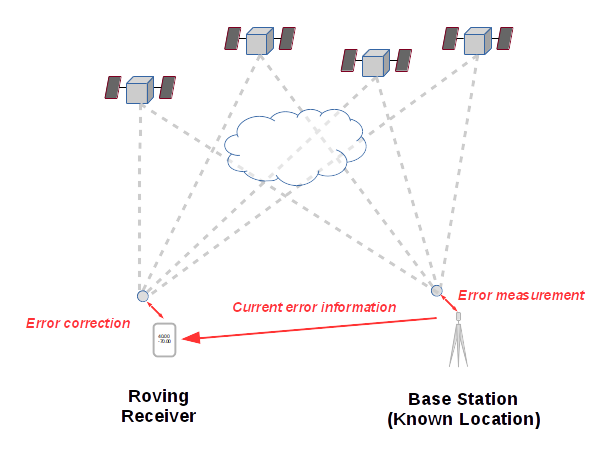
Most techniques for improving accuracy rely on some variant of differential GPS. Differential GPS uses earthbound base station receivers placed at known locations that calculate the current amount of error in the area, and then transmit that information to nearby "roving" GPS receivers so they can compensate for that error in estimating their location. Real-time differential GPS is complex and usually limited to professional-grade receivers, such as those used in aircraft avionics or professional surveying.
While the normal accuracy of consumer grade GPS receivers is &plusmin;5 meters (16 feet)
(van Diggelen and Enge 2015),
differential GPS with professional grade
equipment can improve that to ±80 centemeters (around 2.6 feet) with conventional differential GPS
and ±2 centimeters with real-time kinematics
(Racelogic 2021).
Base Stations
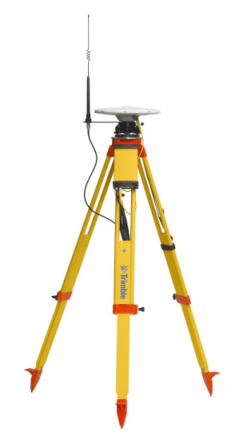
For construction and surveying application, portable base stations can be set up on benchmarks or known locations.
Satellite-Based Augmentation Systems (SBAS)
Satellite-based augmentation systems use communications satellites to transmit error compensation information from fixed base stations.
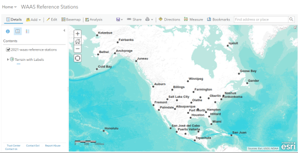
The US FAA operates the Wide Area Augmentation System (WAAS), which includes 38 reference (base) stations across North America. The reference stations each have three GPS receivers. Error information is sent to master stations to be combined into augmentation information. That information is uplinked to geostationary communications satellites to be relayed to aircraft. The aircraft GPS receivers then use that information to adjust GPS location information to greater accuracy.
Real Time Kinematics
Real time kinematics (RTK) is a technique that uses differences in the phase of carrier signals between the base station and rover station to provide error compensation information. This technique requires more sophisticated (and expensive) base station and roving receivers than older differential GPS techniques. The distance between the base station and roving receiver is also limited to 10 - 20 kilometers.
However, accuracies of a few centimeters are possible, making RTK extremely useful for GPS surveying (ESA 2021).
The NOAA / National Geodetic Survey Continuously Operating Reference Stations (CORS) network of RTK base stations in the US.

Non-US GNSS Systems
BeiDou (aka Compass) is a Chinese GNSS system that began deployment in 2000 and achieved full global coverage in 2020.
GLONASS is a Russian GNSS system which began deployment in 1982 and, after a decline in capacity during the economic and political chaos of the 1990s, was fully restored to a 24-satellite constellation in 2011.
Galileo is a European GNSS system that began deployment in 2011 that has around 28 operational satellites.
GPS Security and Reliability Issues
The increasing use of GPS by a variety of business in mission-critical applications (including transportation systems) raises concerns about the security and future of the Global Positioning System.
A 2011 report by the US Department of Homeland Security noted that, The increasing convergence of critical infrastructure dependency on GPS services with the likelihood that threat actors will exploit their awareness of that dependency presents a growing risk to the United States.
GPS was originally a military system and GPS is now integral to modern warfare. Accordingly, the military has to consider:
- Vulnerability of GPS to jamming, spoofing and hacking
- Vulnerability of satellites to failure or physical destruction
- Contingencies for operations if GPS is degraded or denied
There is even the possibility that the failure of government leaders to adequately fund critical system maintenance and upgrades could lead to system degredation or failure. A 2009 GAO report questioned whether the Air Force will be able to acquire new satellites in time to maintain current GPS service without interruption. While that crisis seems to have abated, given the sclerotic political climate in Washington and the long-range planning needed to keep GPS functioning, it is not inconceivable that the worst enemy of GPS may end up not being a foreign force, but ourselves.